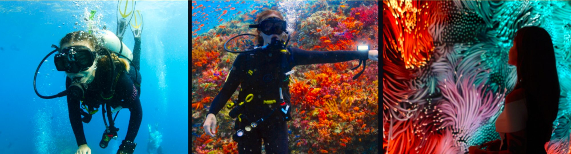
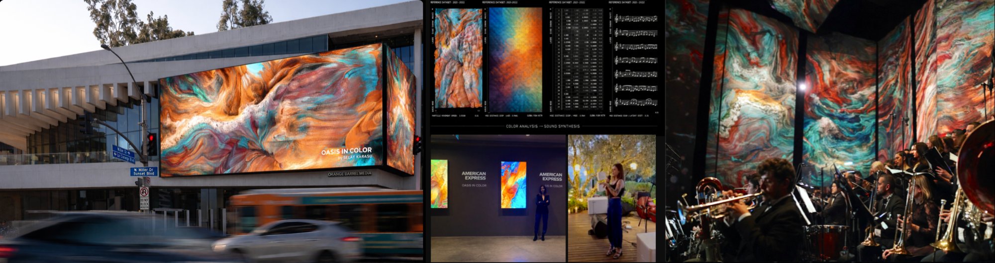
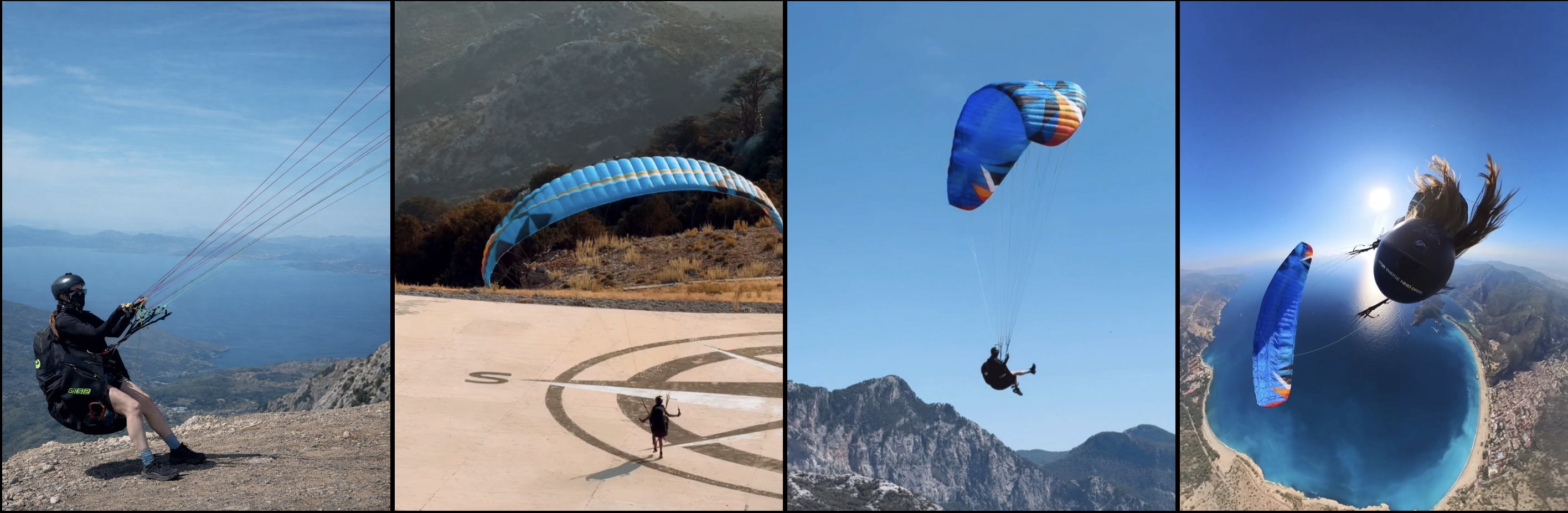
QUALIA

SILENT EXPLORATION. FORCES, TRANSLATED.

NATURE SPEAKS IN DATA.
QUALIA translates it into art.
THE HUMAN BODY BECOMES THE INTERFACE.
EXTREME ENVIRONMENT BECOMES THE SIGNAL.

Scroll
Field Intelligence · Live Sensor Array Alps · Himalayas · Andes · Atlas · GDR · 2026 Wind Speed 18.4 KT · Alt 4,250M · HRV 64MS Generative Translation · Data Becomes Art Not Simulated · Not Archived · Live Selay Karasu · Artist & Pilot The Mountain Does Not Become A Metaphor · It Becomes The Algorithm Field Intelligence · Live Sensor Array Alps · Himalayas · Andes · Atlas · GDR · 2026 Wind Speed 18.4 KT · Alt 4,250M · HRV 64MS Generative Translation · Data Becomes Art Not Simulated · Not Archived · Live Selay Karasu · Artist & Pilot The Mountain Does Not Become A Metaphor · It Becomes The Algorithm
MANIFEST

QUALIA
2026

TRANSLATED FORCES
HUMAN BODY AS SENSORY INSTRUMENT
365-DAY CONTENT ENGINE
GLOBAL EXHIBITIONS & LEGACY

QUA·LIA  /ˈkwälēə/

The internal and subjective component of sense perceptions, arising from the way we individually experience the world.

MANIFEST

NATURE DOES NOT COMMUNICATE IN LANGUAGE.

IT COMMUNICATES IN ELEVATION SHIFTS, SURFACE RESISTANCE, GEOLOGICAL TENSION — IN THE SLOW MEMORY OF THE EARTH. IT COMMUNICATES IN PRESSURE DIFFERENTIALS, THERMAL GRADIENTS, ELECTROMAGNETIC FIELDS, AND ATMOSPHERIC TURBULENCE.

NATURE SPEAKS IN DATA.

QUALIA IS A TRANSLATION SYSTEM.

EACH EXPEDITION STAGE CAPTURES RAW ENVIRONMENTAL SIGNALS — TERRAIN INCLINATION, GROUND COMPOSITION, ALTITUDE, WIND SPEED, TEMPERATURE FLUX, AND THE HUMAN BODY WITHIN IT. HEART RATE. BREATH. OXYGEN LEVELS. FEAR. NOT AS SEPARATE INPUTS, BUT AS A SINGLE FIELD OF INTERACTION.

THE BODY BECOMES A SENSING INSTRUMENT, REGISTERING THE ENCOUNTER BETWEEN HUMAN AND EXTREME NATURE IN REAL TIME.

THESE SIGNALS ARE NOT INTERPRETED.
THEY ARE TRANSFORMED — INTO VISUAL, SONIC, AND SPATIAL FORMS.

THE OUTPUT IS NOT ILLUSTRATION. IT IS A DIRECT MATERIAL CONSEQUENCE OF FORCE.

DATA IS NOT EXTRACTED. IT IS EMBODIED.

QUALIA DOES NOT OBSERVE NATURE. IT BECOMES PART OF ITS SENSING SYSTEM.

WE ARE ENTERING A DECADE WHERE DATA WILL DEFINE CULTURE.

QUALIA EXISTS AT THAT THRESHOLD —
NOT AS A PREDICTION,
BUT AS A PRACTICE.

SELAY KARASU ARTIST · PILOT · RESEARCHER
01 — THE CONCEPT: TRANSLATED FORCES

A SYSTEM BUILT THROUGH
EXPOSURE.

QUALIA is not a data visualization project. It is a system for translating invisible forces into human experience.

While most data is extracted, analyzed, and reduced — QUALIA is embodied. It captures the feeling of an environment, its unique Qualia, and translates it into a visceral, immersive language.

The mountain does not become a metaphor.
It becomes the algorithm.

A multi-continental expedition through earth and air — collecting live environmental data in extreme terrain, transformed into large-scale generative art.

Back in the studio, readings of wind speed, altitude, and biometric stress are not analyzed — they are translated into light, movement, and density.

This is not observation.
It is exposure.

Enter the Atmosphere
TERRAIN EXPLORATION
01
TERRAIN EXPLORATION
GROUND TELEMETRY
EMBODIED MOVEMENT
02
EMBODIED MOVEMENT
AERIAL EXPERIENCE
03
AERIAL EXPERIENCE
DATA COLLECTION
DATA INTO DIGITAL ART
04
DATA INTO DIGITAL ART
VISION

ENVIRONMENTAL
INTELLIGENCE

QUALIA DOCUMENTS ENVIRONMENTAL INTELLIGENCE — THROUGH DIRECT HUMAN EXPERIENCE WITHIN A LIVING ATMOSPHERIC SYSTEM.

QUALIA IS A YEAR-LONG, SEVEN-STAGE EXPEDITION ART PROJECT. ARTIST AND LICENSED PARAGLIDING PILOT SELAY KARASU WILL TRAVERSE SEVEN EXTREME GEOGRAPHIC ZONES: ALPS, HIMALAYAS, ANDES, ATLAS, SAHARA, GREAT DIVIDING RANGE, AND ANATOLIA, WEARING A FULL BIOMETRIC SENSOR ARRAY AND ATMOSPHERIC MONITORING EQUIPMENT.

EVERY PHYSIOLOGICAL AND METEOROLOGICAL SIGNAL CAPTURED BECOMES RAW MATERIAL FOR A BODY OF WORK THAT TRANSLATES INVISIBLE NATURAL FORCES INTO ART.

FIVE
CONTINENTS.
SEVEN
MOUNTAINS.
ONE BODY.
ONE YEAR.
THE PLANET SPEAKS.
QUALIA RECORDS IT.
ATMOSPHERIC VIDEO FEED · FIELD CAPTURE · LIVE TEXTURE
Motion Sample ◈ ACTIVE
02 — WHY IT MATTERS

THE INVISIBLE
NEVER BEEN MORE
VISIBLE.

There is no drone footage here. No remote sensing.
Selay enters the terrain at human speed, under human risk,
with her own cardiovascular system wired into the data stream.
The work is not about nature from a distance.

QUALIA DOES NOT DOCUMENT ENVIRONMENTAL CRISIS. IT DOCUMENTS ENVIRONMENTAL INTELLIGENCE — THE PRECISE, BEAUTIFUL COMPLEXITY OF A LIVING ATMOSPHERIC SYSTEM. EVERY EXPEDITION ADDS TO A GROWING ARCHIVE OF WHAT THE PLANET SOUNDS LIKE IN DATA.

THE BODY Atmospheric Layer Wind · Pressure · Thermal · CO₂ · Altitude
THE PLANET Vehicle Telemetry Layer Slope · Traction · Surface Temp · Elevation · Distance
DATA Translation Layer Custom algorithms · Real-time processing · Field-to-studio pipeline
ART Output Layer Large-format work · Global exhibition · Permanent record
Live Telemetry Stream · QUALIA Sensor Array · Status: Active UTC 00:00:00
WIND
18.4 KT
Aero-Dynamics · Wind Speed
ALT
4,250 M
GPS Altitude · Barometric
G-FORCE
3.2 G
Inertial Measurement Unit
HRV
64 MS
Heart Rate Variability · Bio
O₂ SAT
94.2 %
Oxygen Saturation · Biometric
COORD
45.8327° N
GPS · WGS84 Datum
TURB
0.38 EDR
Turbulence Index · ICAO
CO₂
412 PPM
Carbon Density · Env.
Hardware: High-fidelity multi-sensor array · custom harness Software: Custom generative translation engine · real-time pipeline
03 — THE ARTIST

SELAY
KARASU

Generative Media Artist · Paragliding Pilot

For over two decades, Selay has built a practice at the intersection of environmental data and large-scale visual experience — from satellite climate archives to month-long field residencies on four continents. Her work has been presented at MoMA New York, Times Square, CERN Geneva, Art Basel, and Burning Man. QUALIA is not her largest project. It is her most precise.

II — THE METHODOLOGY: THE ARTIST AS A SENSORY INSTRUMENT

The Pilot-Artist

Selay Karasu utilizes her expertise as a professional paragliding pilot to enter environments inaccessible to most — positioning herself not as an observer but as a human sensor within the sky. Data is not collected; it is lived.

The Physicality of Data

Data is generated through altitude stress, wind resistance, G-force, and risk. This is not simulation. This is exposure to real forces.

21yrSatellite Climate Data
4+Ocean Expeditions
10+Global Platforms
5Continents · Acquisitions
Selay Karasu — Artist & Pilot
Solo Exhibitions
Canada
Japan
Public Art
Times Square NY
Miami · Tokyo
Singapore · AU
Platforms
MoMA NY
Burning Man
CERN Geneva
Art Basel
Acquisitions
USA · Canada
Europe · AU
Asia
04 — MILESTONES
w/ Chikai Ohazama
Creator of
Google Earth
21-Year Climate Archive

Two decades of satellite data translated into generative art with Google Earth's co-creator. Lead work acquired across New York, Miami, Europe, and Canada.

NY AcquisitionMiamiEuropeCanada
Satellite Climate Data
CERN Particle Physics Laboratory
Art Residency
CERN Residency

One month embedded with physicists at CERN Geneva. Works shown at Burning Man, Art Basel Miami, and MoMA New York.

Burning ManArt BaselMoMA NY
Particle Physics Residency
w/ Bill Joy
Edison of the Internet
Four-Ocean Field Study

Coral bleaching surveys across the Caribbean, Atlantic, and Indian Oceans. Field data translated into works acquired by prominent American collectors.

CaribbeanAtlanticIndian Ocean
Marine Ecosystems Research
in collab with
American Express
Intelligence vs. Hand

Reverse-engineered model mapping AI production against human authorship. Color translated to music. Works held in private collections of select American Express cardholders.

Private CollectionsAMEX
AI & Human Creation
05 — IN THE FIELD

PILOT
IN ACTION.

Paragliding prep
Paragliding launch
Paragliding in flight
Paragliding acrobatics
06 — PROJECT SCOPE

SEVEN
TERRAIN ZONES.
ONE ROUTE.

Five continents. One atmospheric corridor. Each stage leaves a different signal on the body — and on the data.

WP-01
Route 01 · Europe
ALPS
High-altitude ridgelines · glacial wind corridors · extreme turbulence data
45.8327°N · 06.8652°E
4808 M · MONT BLANC
WP-02
Route 02 · Asia
HIMALAYAS
Extreme altitude barometry · low oxygen biometrics · stratospheric approach
28.5921°N · 83.8200°E
8091 M · ANNAPURNA I
WP-03
Route 03 · South America
ANDES
Volcanic terrain geometry · cross-hemisphere wind patterns · remote telemetry
13.1631°S · 72.5450°W
3399 M · CUSCO REGION
WP-04
Route 04 · Africa
SAHARA
Maximum carbon density · thermal plumes · desert-scale atmospheric optics
20.8333°N · 17.4500°E
3415 M · TIBESTI MASSIF
WP-05
Route 05 · Australia
GREAT DIVIDING
RANGE
Subtropical ridge systems · humidity gradients · unique geospatial data signatures
36.4566°S · 148.2635°E
2228 M · MT KOSCIUSZKO
WP-06
Route 06 · North America
ROCKIES
Continental divide corridor · altitude pressure differentials · thermal boundary layers
39.1178°N · 106.4453°W
4399 M · MT ELBERT
WP-00
Atmospheric Bridge
ANATOLIA
Atmospheric convergence · east-west pressure bridge · environmental intelligence threshold
39.0000°N · 35.0000°E
TRANSITION ZONE
OUTPUT PLATFORMS
4 DISTRIBUTION CHANNELS · 2026–2028
Platform 01
PHYSICAL MUSEUM
EXHIBITIONS

Global touring exhibition — Art Basel, CERN venues, institutional galleries

Platform 02
8K DOCUMENTARY
FILM

Cinematic long-form record of each expedition — festival and broadcast distribution

Platform 03
REAL-TIME WEB
DASHBOARD

Live telemetry visualization — public-facing data stream during active expeditions

Platform 04
LIMITED EDITION
PHYGITAL ARTWORKS

NFT/Print hybrid editions — certified, numbered, and archived as permanent cultural objects

GLOBAL EXPEDITION MAP · 2026 ROUTE
7 WAYPOINTS 5 CONTINENTS ACTIVE
Tracking Active · QUALIA / 2026
LAT: ---.--°    LON: ---.--°
SIG 000726
60°N30°N EQ30°S60°S 60°W 60°E 120°E ANDES GLACIATED CORDILLERA ALT 6271 M SAHARA VOLCANIC DESERT MASSIF ALT 3415 M ALPS GLACIATED GRANITE MASSIF ALT 4806 M ANATOLIA STRATOVOLCANIC MASSIF ALT 3917 M HIMALAYAS GLACIATED HIGH-RELIEF RANGE ALT 8091 M GT. DIV. RANGE ALPINE GRANITE MASSIF ALT 2228 M ROCKIES ALPINE TUNDRA GRANITE ALT 4401 M LAT — LON — WIND —
Wind Feed
Open Ocean Sweep
Cursor active · wind layer standby
Telemetry Feed
Open Ocean Sweep
Cursor active · regional scan online
LAT ---.--° · LON ---.--° SCAN
Western Arc
Eastern Arc
Selay Karasu — Expedition
QUALIA / 2026
SELAY KARASU · FIELD RECORD
2026 ACCESS LIMITED INTEGRATION POINTS

ENTER
THE
ATMOSPHERE

7 STAGES · 5 CONTINENTS · 1 RECORD

A LIMITED NUMBER OF INTEGRATION POINTS — OPEN ANNUALLY.
2026 IS ACTIVE.

PARTNER WITH WHAT THE PLANET RECORDS.

Copied to clipboard
BEYOND QUALIA ENTER PRIVATE PAGE

Already approved? Enter the private page directly and unlock it with your access code.

WIND 18.4 KT ALT 4,250 M HRV 64 MS STATUS: ACTIVE
Enter Access Code
Awaiting access code.